


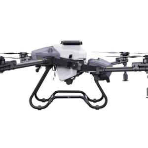
2B Mapper – Precision Survey UAV
The 2B Mapper is a professional UAV system designed specifically for precision agricultural and industrial aerial surveying. It is capable of producing high-resolution orthophotos, NDVI maps and 3D models.
Technical Specifications
- High coverage capacity: up to 50 km²/day
- High-resolution camera: RGB + multispectral option
- RTK/PPK GPS accuracy: ±2–3 cm
- Flight time: up to 55 minutes (battery dependent)
- Wind resistance: up to 12 m/s
- Automated mission planning and execution
Applications
- Agricultural area survey and crop health analysis
- Greenhouse roof and structure inspection
- Topographic mapping
- Infrastructure inspection
- Land boundary determination
Data Processing
After the flight, collected imagery can be processed with photogrammetry software (Pix4D, DJI Terra, Agisoft Metashape) into orthophotos, elevation models (DEM/DSM) or 3D point clouds.
Purchase & Deposit
The price of the Drone2B Mapper is 5,020,141 HUF. At checkout you can choose to pay the full amount or just a 50% deposit — the remaining balance is due before delivery. For a custom configuration, feel free to request a tailored quote.
Reviews
There are no reviews yet.